Montgomery County is looking to construct a cycle track (aka protected bike lanes) on Woodmont Avenue between Old Georgetown Road and Bethesda Ave. The project would allow cyclists to ride either north or south on Woodmont in some combination of cycle tracks and conventional bike lanes. See this detailed analysis of the various options. Much of Woodmont is a one-way street, so any facility allowing northbound travel would be a definite improvement, protected or otherwise.
A key question is what will the rest of Woodmont Ave look like? What bike accommodations will it get? I’m referring to the half-mile long stretch of Woodmont Ave from Old Georgetown Road to Battery Lane, which is a two way street. The future design has to be anticipated by the current project. No project is an island (unless of course it is).
Woodmont Ave as it looks today:
I came up with three bike options, shown in these representative cross-sections:
Choose carefully!
(Feb. 24, 2015 update. A fourth option, conventional bike lanes, is depicted at the end of this post).
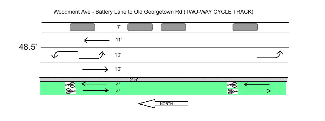
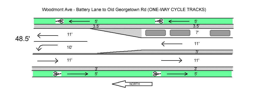
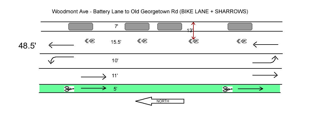
To cut to the chase, the first option among the three above – a two-way cycle track – is the weakest for significant safety reasons and because of ramifications further south. The second option – a pair of one-way cycle tracks – is the best protected solution, but requires removing two lanes somehow. The third option, bike lanes on one side and sharrows on the other, is in all likelihood the best solution that only requires removing one lane, but it will intimidate some riders.
The street today
The segment of Woodmont between Battery Lane and Old Georgetown Road is 48.5′ wide (including gutters) everywhere I measured it. It generally has five lanes. There are two main travel lanes in each direction. There is a center lane that serves as a turn lane with the occasional median island in the way. In many stretches, one or both outer lanes are used for parking.
There are several parking lot or garage entrances on both sides. Within the segment (excluding the endpoints) there are four cross streets on the west side, three on the east side. Four of the intersections are signalized and three are skewed at a 45-degree angle. Many people might feel uncomfortable biking there, but I would not characterize riding there as daunting or dangerous. Traffic generally does not move quickly and blocks are short. But it’s possible that drivers wouldn’t be able to pass a cyclist right away. With simple bike lanes, cyclist comfort levels would increase quite a bit. The county master plan calls for bike lanes on all of Woodmont (presumably cycle tracks would qualify).
Road diet?
I would imagine the county is amenable to removing one of the five lanes in order to provide bike accommodations. Removing two lanes would take more lobbying, but would free up space for conventional bike lanes or one-way cycle tracks. It’s certainly doable, since the turn lanes could be shortened and on-street parking provided wherever there’s no turn lane. Or the street could be re-conceived to look more like Norfolk Ave (but with parking on only one side), with stop signs in place of traffic signals, reducing the need for turn lanes. (I can relate two harrowing experiences at intersections there as a pedestrian – both involving drivers ignoring signals but and none involving stop signs. Does no one stop before turning right on red any more?)
But if only one lane can be removed, there would only be room for either a two-way cycle track or a hybrid of a conventional bike lane on one side and sharrows on the other, similar to the original Woodglen Drive proposal (the two roads have almost identical dimensions).
Comparison of the options
A one-way facility type north of Old Georgetown Road (one-way cycle tracks, bike lanes, sharrows or sharing the road) would allow for a better configuration south of Old Georgetown Road under the current project. The facility could be one-way all the way from Bethesda Ave to Battery Lane, requiring no transitions at all! Another point is the fact that the south configuration must be “backward compatible” with the existing north configuration as well as support the future north configuration. If the existing north configuration and the future one are both one-way bikeway types, the south configuration only has to interface to one north configuration.
But the biggest strike against the two-way cycle track solution is safety. Riders would have to cross a great many parking lot exits and weirdly-angled side streets while riding in the “wrong” direction from a driver’s perspective. He or she would have to ride very slowly and cautiously, since just one driver who failed to look right as well as left could ruin the cyclist’s day in a big way.
If there’s an upside to the two-way cycle track option (assuming it’s on the west side), it would be that it allows more convenient access to the Norfolk Ave street grid and the Bethesda Trolley Trail, which are located west of Woodmont.
A pair of one-way cycle tracks is a much better option. Even it has some negatives, however, like the awkwardness of making left turns and the likelihood of pedestrians in the cycle track. It’s quite possible that the volume and speed of traffic on Woodmont Ave does not justify the impact on bicyclists. But if the goal is a protected facility, it’s the best option.
If the county can’t find a way to remove two lanes from this five lane road, then the bike lane + sharrow solution is the best in terms of safety and speed, even if it’s not the most “protected” or comfortable for some riders.
I haven’t considered the option of providing a two-way cycle track south of Norfolk and standard bike lanes/sharrows north of Norfolk. It might be acceptable if the transition can be worked out, providing a safer facility north of Norfolk while keeping the better bike access to the Bethesda Trolley Trail associated with a two-way cycle track leading up to Norfolk.
Feb. 24, 2015 Update:
I just want to highlight an additional option, which is to provide standard bike lanes while still retaining continuous parking on one side.
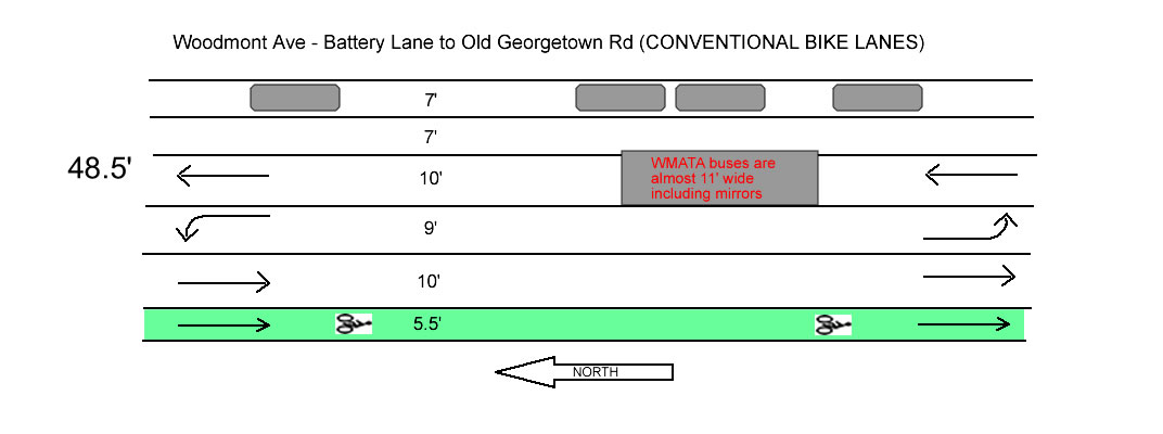
In this case the lanes are quite narrow, but it does meet county width standards and keeps cyclists out of the door zone. Buses are as wide as 11′ so you’d quickly realize how tight this is. Striping crews also routinely paint lines 3-6 inches off target, so some lanes might be narrower than intended.
A similar solution is being provided on Clinton Street in Concord, NH, which carries 11,000 vehicles a day. Some parts of Clinton St. are being striped with a 5’ bike lane/shoulder against the curb, 10’ through lane, 9’ left turn lane, 10’ lane through lane, 5’ bike lane, and 10’ right turn lane against the curb (Woodmont would have a 7′ parking lane instead of the 10′ right turn lane). According to the bike planner there, it works because there isn’t much turning traffic, allowing left-turning vehicles to encroach into the center lane. Google maps shows the current but not yet completed configuration.
Note: If you post a comment and it’s not approved within an hour, please send a blank email to email@mobike.org with the subject “approve” or something like that. WordPress is having difficulties – sorry for the inconvenience.